A Guide to the Best Hiking in the East Bay
Rolling hills, panoramic views, wildflowers, shady creeks, and unexpected treasures like volcanoes and redwood forests define East Bay Area hiking
I love exploring the regional and state parks in the East Bay because they offer an easy, convenient escape from the city into the outdoors. Here, a local’s guide to the best trails in the East Bay, which showcase the variety of natural havens in the region—all within less than an hour’s drive from Concord.
1. Eagle Peak Loop
Location: Mount Diablo State Park, Clayton Difficulty: Strenuous Distance: 7.6 miles
The hike up Eagle Peak in Mount Diablo State Park will challenge even the most seasoned hikers—and reward them with incredible views. From the trailhead on Mitchell Canyon Road, start on the gently rising Mitchell Canyon Fire Road trail, where you’ll enjoy tranquil green scenery along the creek. The challenge begins in earnest after about two miles, where you’ll climb switchbacks before the final, easier ascent along the ridgeline to the summit of Eagle Peak at 2,369 feet. I take this as my chance to rest and savor the panoramic views before descending the last 2.7 miles on Eagle Peak Trail back to the trailhead.
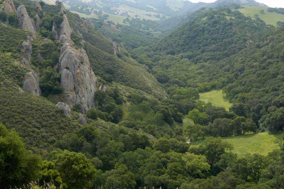
2. Waterfalls of Mount Diablo Loop
Location: Mount Diablo State Park, Clayton Difficulty: Difficult Distance: 5.8 miles
Winter and spring rains in the Bay Area create an abundance of seasonal waterfalls, especially at Mount Diablo State Park. To witness these impressive cascades, park at the Mitchell Canyon entrance and head up Donner Canyon Trail. From there, continue straight onto the Falls Trail—and expect to climb about 1,100 feet in the first 2.5 miles. Complete the loop on the Middle Trail and Back Creek Trail, where you’ll face one more climb and see one more waterfall (the circuit showcases six waterfalls in total).
3. Rocky Ridge View Trail to Elderberry Trail Loop
Location: Las Trampas Regional Wilderness, Danville Difficulty: Moderate Distance: 4.7 miles
The 5,432-acre Las Trampas Regional Wilderness is one of my favorite places in the East Bay for escaping the city and immersing in solitude. Park at the trailhead at the end of Bollinger Canyon Road and then climb steadily for about a mile on the Rocky Ridge View Trail (be sure to stay left to avoid the gate near the top). It’s mostly downhill the rest of the way as you hike along the ridge, with unparalleled views of Mount Diablo and the Bay Area unfurling in the distance. Take a right at the junction with Elderberry Trail to return to the trailhead, soaking up glorious views of wildflowers in season.
4. East Ridge to West Ridge Loop
Location: Redwood Regional Park, Oakland Difficulty: Moderate to Difficult Distance: 8.3 miles
Explore a rare forest of 150-foot redwoods just 20 miles from Concord. Start from the Skyline Gate Staging Area and follow the West Ridge Trail through dense redwood and evergreen forests. Then, dip down toward Redwood Creek on Bridle Trail and back up Canyon Trail, which will connect you to the East Ridge Trail (turn left). The remaining 2.8 miles on the East Ridge feature more forested bliss and picturesque vistas over the rolling valleys.
5. Pleasanton Ridge Trail
Location: Pleasanton Ridge Regional Park, Pleasanton Difficulty: Moderate Distance: 6.2 miles
To explore these grassy hillsides dotted with immense oak trees, start at the Foothill Staging Area. Hike up the first hill on Oak Tree Trail and then traverse the western side of the ridgeline on the Thermalito Trail. Loop around to the Ridgeline Trail, which runs along the eastern side and features sprawling views of Pleasanton, Livermore Valley, and the surrounding East Bay peaks. Descend on the steeper Woodland Trail—my favorite section of any Pleasanton Ridge outing—under the shaded canopy or oaks.
6. Diablo View Trail to Alhambra Creek Loop
Location: Briones Regional Park, Martinez Difficulty: Moderate Distance: 2.4 miles
Briones Regional Park holds a world of rolling grassy hills right in the heart of Contra Costa County. Despite its proximity to the cities, Briones feels like a hidden oasis with views of nothing but nature from many points in the park. Start on the Diablo View Trail from the trailhead at the end of Brockwood Drive in Martinez. After about 1.1 miles of uphill, turn right on the Spengler Trail for one-third mile. Take a right onto the Alhambra Creek Trail, which gently descends through oak and grasslands beside the namesake creek back to the trailhead.
7. Round Top Loop to Volcanic Trail to Skyline Trail Loop
Location: Robert Sibley Volcanic Regional Preserve, Oakland Difficulty: Easy Distance: 3.5 miles
This hike showcases one of the most unlikely natural features found in the Bay Area: a volcano! The 1,763-foot Round Top volcano is the headliner, and its lava flows, which date back some 10 million years, deposited most of the volcanic rock now seen throughout the preserve. To explore this geologic wonder, start at the Sibley Staging Area east of Oakland. Use the paved Overlook Trail to get to the visitor center, where you can pick up a map for the self-guided volcanic tour. Hop onto the Round Top Loop Trail for 360-degree views of the Bay. Turn left onto Volcanic Trail, which hosts most of the points of interest from the tour. Connect onto the paved Quarry Road, then turn left on Skyline Trail back to the trailhead.
8. Wildcat Gorge to Meadows Canyon Trail Loop
Location: Tilden Regional Park, Berkeley Difficulty: Easy Distance: 3.3 miles
One of the oldest preserves in the East Bay, Tilden Regional Park delights visitors with forested expanses, wildflowers, rocky creeks, and unique attractions like the free botanic garden, plant nursery, farm, and environmental education center. From the Lake Anza parking lot, walk along the shore on the Lake Anza Trail toward Wildcat Gorge Trail. Wildcat Gorge heads mostly downhill along the creek before the junction with Meadows Canyon Trail, where you’ll turn right. Meadows Canyon is a gentle uphill with sprawling views that brings you to the Curran Trail (turn right). At the end of the Curran Trail, retrace your steps back to Lake Anza Trail and the parking lot.
*Main Image Photo Credit to Scott Hein Photo*